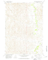
1972 Map of Somerville Flats West
USGS Topo · Published 1975About this map
The Powder River meanders through the eastern portion of this Johnson County landscape, creating a fertile riparian corridor against the surrounding high plains. This 1970s survey, conducted as part of the Missouri River Basin development program, documents a terrain defined by extensive drainage systems including Deer Gulch, Coal Gulch, and the North Fork Coal Gulch. The presence of a Landing Field near Barber Creek and various Flowing Well sites suggests the specialized aviation and water management needs of the local ranching economy. To the south, Flying E Creek and Bridge Draw cut through the topography toward the eponymous Somerville Flats. Evidence of resource exploration is visible at the Drill Hole site in the southwest, while numerous benchmarks like BM 3885 provide precise data points across this part of the Wyoming interior.
Find a feature on this map
17 named features on this map. Tap any name to fly to it.
Don’t see what you’re looking for? This feature index may not catch every label — zoom into the map to look around manually.
Map Details
Editions of this 1972 Somerville Flats West Map
This is the sole edition of this map. No revisions or reprints were ever made.
Other maps of this area

1955 · Sheridan
USGS Topo · 1:250,000

1958 · Sheridan
USGS Topo · 1:250,000

1962 · Sheridan
USGS Topo · 1:250,000

1972 · Mitchell Draw
USGS Topo · 1:24,000
1972 · Ploessers Draw
USGS Topo · 1:24,000
1972 · Laskie Draw
USGS Topo · 1:24,000
1972 · Bear Draw
USGS Topo · 1:24,000
1972 · Floate Draw
USGS Topo · 1:24,000
1972 · Juniper Draw
USGS Topo · 1:24,000
1972 · Livingston Draw
USGS Topo · 1:24,000