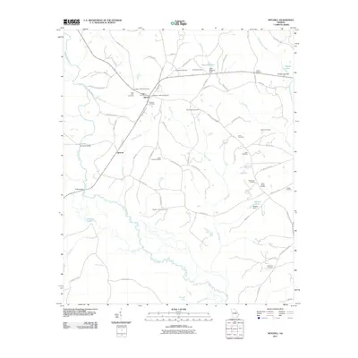
2011 Map of Mitchell
USGS Topo · Published 2011About this map
The Ogeechee River meanders through the western half of this Glascock County quadrangle, defining a landscape of agricultural roads and rural settlements at Mitchell and Agricola. This area is characterized by a dense concentration of family and community burial grounds, providing significant genealogical resources. Features such as the Kitchens - Wilcher Cemetery, Llewellyn - Kitchens Cemetery, and Braddy - Hilson Cemetery reflect the long-standing family lineage within the community. Water management for local use is evident in landmarks like Kents Millpond and Roberts Lake, both secured by named dams. The road network, including names like Edgehill Mitchell Rd and Gus Walden Rd, connects these small hubs across Philcher Creek and Big Creek, illustrating the persistent rural structure of this Georgia region.
Find a feature on this map
79 named features on this map. Tap any name to fly to it.
Don’t see what you’re looking for? This feature index may not catch every label — zoom into the map to look around manually.
Map Details
Editions of this 2011 Mitchell Map
This is the sole edition of this map. No revisions or reprints were ever made.
Other maps of this area

1953 · Athens
USGS Topo · 1:250,000

1958 · Athens
USGS Topo · 1:250,000

1959 · Athens
USGS Topo · 1:250,000

1960 · Warthen NE
USGS Topo · 1:24,000

1961 · Warthen
USGS Topo · 1:24,000

1963 · Athens
USGS Topo · 1:250,000

1971 · Beall Springs
USGS Topo · 1:24,000
1972 · Downs
USGS Topo · 1:24,000
1972 · Bastonville
USGS Topo · 1:24,000
1972 · Gibson
USGS Topo · 1:24,000