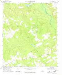
1972 Map of Downs
USGS Topo · Published 1974About this map
Downs and Halls Crossing anchor this rural landscape in eastern Georgia, where the winding Ogeechee River defines the boundary between Jefferson and Washington Counties. The map reflects a deeply rooted community structure, evidenced by the numerous small rural congregations such as Halls Chapel, White Oak Ch, and May Branch Ch. This 1970s survey captures the region's agricultural and hydrologic character, dominated by the drainage systems of Williamson Swamp Creek and Stephens Creek. Smaller water features like Jordan Millpond and Archers Lakes suggest the historical importance of water management for local use. For researchers, the presence of family-linked landmarks like Minton Springs Cem and small infrastructure such as Heidrich Airport and a Sandpit provides a clear view of the mid-century intersection between traditional land use and local industry.
Find a feature on this map
22 named features on this map. Tap any name to fly to it.
Don’t see what you’re looking for? This feature index may not catch every label — zoom into the map to look around manually.
Map Details
Editions of this 1972 Downs Map
2 editions found
Other maps of this area

1953 · Athens
USGS Topo · 1:250,000

1957 · Macon
USGS Topo · 1:250,000

1958 · Macon
USGS Topo · 1:250,000

1958 · Athens
USGS Topo · 1:250,000

1959 · Athens
USGS Topo · 1:250,000

1960 · Warthen NE
USGS Topo · 1:24,000

1961 · Warthen
USGS Topo · 1:24,000

1962 · Sandersville
USGS Topo · 1:24,000

1963 · Athens
USGS Topo · 1:250,000

1964 · Macon
USGS Topo · 1:250,000