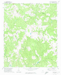
1972 Map of Bastonville
USGS Topo · Published 1974About this map
The Central Of Georgia railroad corridor cuts diagonally across this rural landscape, serving as a primary transit artery between the small settlements of Harts and Bastonville. This early 1970s topographical record captures the agricultural and timber character of the borderlands between Glascock, Warren, and McDuffie counties. The terrain is defined by a dense network of tributaries including Rocky Comfort Creek and Little Brier Creek, which feed into numerous named branches such as Storm Branch and Darden Branch. Social life in this era is anchored by dispersed country churches, including Little Brier Creek Ch, Stamp Branch Ch, Magnolia Ch, and Thankful Ch, several of which are accompanied by small cemeteries. The presence of a pipeline and a jeep trail in the western reaches suggests industrial and recreational utility amidst the heavily wooded branches and ridges of the Georgia interior.
Find a feature on this map
30 named features on this map. Tap any name to fly to it.
Don’t see what you’re looking for? This feature index may not catch every label — zoom into the map to look around manually.
Map Details
Editions of this 1972 Bastonville Map
This is the sole edition of this map. No revisions or reprints were ever made.
Other maps of this area

1920 · Stapleton
USGS Topo · 1:62,500

1922 · Harlem
USGS Topo · 1:62,500

1948 · Harlem
USGS Topo · 1:62,500

1948 · Stapleton
USGS Topo · 1:62,500

1948 · Thomson East
USGS Topo · 1:24,000

1950 · Dearing
USGS Topo · 1:24,000

1950 · Wrens
USGS Topo · 1:24,000
1950 · Bowdens Pond
USGS Topo · 1:24,000

1953 · Athens
USGS Topo · 1:250,000

1958 · Athens
USGS Topo · 1:250,000