
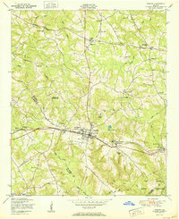
1950 Map of Dearing
USGS Topo · Published 1950About this map
The Georgia railroad corridor anchors this mid-century portrait of McDuffie and Columbia Counties, connecting the larger community of Thomson with the smaller settlements of Boneville and Dearing. This transportation spine is paralleled by a network of telephone or telegraph lines, illustrating the rural infrastructure of the late 1940s. The landscape is characterized by a dense concentration of local institutions and family landmarks, including the St Luke Church and School, Farr School, and Mt Gilead School. Genealogists will find significant value in the mapped family burial grounds, such as the Watson Family Cemetery and the Lucy Family Cemetery. The terrain is defined by numerous small water bodies, notably Lokeys Pond and Boatwright Pond, which feed into a complex system of creeks like Kiokee Creek and Sweetwater Creek. This sheet serves as a detailed record of a community defined by its proximity to the rail line and its many country churches, including Salem Church and Cobb Grove Church.
Find a feature on this map
50 named features on this map. Tap any name to fly to it.
Don’t see what you’re looking for? This feature index may not catch every label — zoom into the map to look around manually.
Map Details
Editions of this 1950 Dearing Map
This is the sole edition of this map. No revisions or reprints were ever made.
Other maps of this area

1892 · Mc Cormick
USGS Topo · 1:125,000

1906 · Crawfordville
USGS Topo · 1:125,000

1912 · Mc Cormick
USGS Topo · 1:125,000

1921 · Appling
USGS Topo · 1:62,500

1922 · Harlem
USGS Topo · 1:62,500

1943 · Appling
USGS Topo · 1:62,500

1948 · Harlem
USGS Topo · 1:62,500

1948 · Harlem
USGS Topo · 1:24,000

1948 · Thomson East
USGS Topo · 1:24,000
1950 · Harlem
USGS Topo · 1:24,000