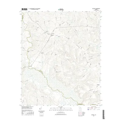
2017 Map of Mitchell
USGS Topo · Published 2017About this map
The Ogeechee River snakes through this landscape, defining the winding boundary between Glascock and Hancock Counties. This area is characterized by a high concentration of small family and community burial grounds, such as the Mitchell Cem, Saint Paul Cem, and the Llewellyn - Kitchens Cem, which offer significant data for genealogical research. The small settlements of Mitchell and Agricola serve as local hubs, connected by a network of rural routes like Agricola Rd and Mitchell Rd. Hydrological features dominate the southern half of the map, where Chalker Lake and the wetlands around Floyd Cr create a distinct terrain from the more elevated northern sections. Significant river crossings, including Harrisons Bridge and Cobb Bridges, highlight the historical transport patterns required to navigate the river's many branches and seasonal floodplains.
Find a feature on this map
114 named features on this map. Tap any name to fly to it.
Don’t see what you’re looking for? This feature index may not catch every label — zoom into the map to look around manually.
Map Details
Editions of this 2017 Mitchell Map
This is the sole edition of this map. No revisions or reprints were ever made.
Other maps of this area

1953 · Athens
USGS Topo · 1:250,000

1958 · Athens
USGS Topo · 1:250,000

1959 · Athens
USGS Topo · 1:250,000

1960 · Warthen NE
USGS Topo · 1:24,000

1961 · Warthen
USGS Topo · 1:24,000

1963 · Athens
USGS Topo · 1:250,000

1971 · Beall Springs
USGS Topo · 1:24,000
1972 · Downs
USGS Topo · 1:24,000
1972 · Bastonville
USGS Topo · 1:24,000
1972 · Gibson
USGS Topo · 1:24,000