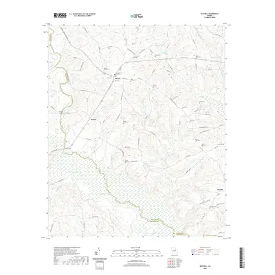
2020 Map of Mitchell
USGS Topo · Published 2020About this map
The Ogeechee River snakes across this Glascock County landscape, defining much of the drainage pattern for the surrounding agricultural and timber lands. The settlement of Mitchell serves as a central point, surrounded by a high density of family burial grounds and small community cemeteries that speak to the deep genealogical roots of the area. Notable sites include the Griffin Family Cem, Llewellyn - Kitchens Cem, and Witcher Cem, many of which are tucked away near rural intersections or historical farmsteads. To the south, the village of Agricola sits near Philcher Cr, while Edgehill occupies the southeastern corner of the survey. The terrain is marked by numerous water bodies and wetlands, such as Kents Millpond, Walden Lake, and the expansive Chalker Lake, which demonstrate the importance of local water resources to the region's historic development and land use.
Find a feature on this map
94 named features on this map. Tap any name to fly to it.
Don’t see what you’re looking for? This feature index may not catch every label — zoom into the map to look around manually.
Map Details
Editions of this 2020 Mitchell Map
This is the sole edition of this map. No revisions or reprints were ever made.
Other maps of this area

1953 · Athens
USGS Topo · 1:250,000

1958 · Athens
USGS Topo · 1:250,000

1959 · Athens
USGS Topo · 1:250,000

1960 · Warthen NE
USGS Topo · 1:24,000

1961 · Warthen
USGS Topo · 1:24,000

1963 · Athens
USGS Topo · 1:250,000

1971 · Beall Springs
USGS Topo · 1:24,000
1972 · Downs
USGS Topo · 1:24,000
1972 · Bastonville
USGS Topo · 1:24,000
1972 · Gibson
USGS Topo · 1:24,000