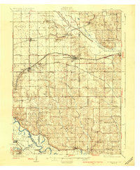
1930 Map of Mitchellville
USGS Topo · Published 1930About this map
Mitchellville sits at the center of this 1920s landscape, serving as a hub for the Chicago Rock Island and Pacific railroad and the U S Highway No 32. The map illustrates a dense network of early 20th-century rural infrastructure, including a remarkably high concentration of one-room schoolhouses like Trullinger Grove Sch, Apple Grove Sch, and Prairie Belle Sch that once anchored these prairie townships. To the south, the Des Moines River meanders toward Adelphi and Runnells, while the Skunk River cuts across the northern reaches near Valeria. This survey provides a precise look at the transition from rail-dependent commerce to the growing highway system, visible in the alignment of State Highway No 88 and the early Des Moines Airport footprint. Local genealogy interest is bolstered by the presence of family-named landmarks and cemeteries such as Mc Keever Cem and Canfield Cem.
Find a feature on this map
86 named features on this map. Tap any name to fly to it.
Don’t see what you’re looking for? This feature index may not catch every label — zoom into the map to look around manually.
Map Details
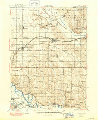
Editions of this 1930 Mitchellville Map
3 editions found
Other maps of this area

1905 · Des Moines
USGS Topo · 1:62,500

1907 · Des Moines
USGS Topo · 1:62,500

1909 · Knoxville
USGS Topo · 1:62,500

1910 · Milo
USGS Topo · 1:62,500

1911 · Slater
USGS Topo · 1:62,500

1912 · Knoxville
USGS Topo · 1:62,500

1913 · Slater
USGS Topo · 1:62,500

1930 · Mitchellville
USGS Topo · 1:62,500

1931 · Indianola
USGS Topo · 1:62,500

1954 · Des Moines
USGS Topo · 1:250,000