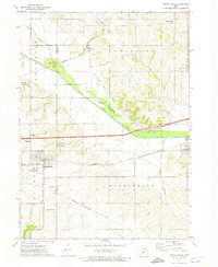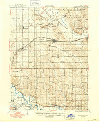
1930 Map of Mitchellville
USGS Topo · Published 1949About this map
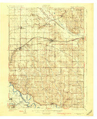
Mitchellville and Colfax anchor this detailed landscape in central Iowa, where the Skunk River and Des Moines River intersect a dense network of early 20th-century transport and education. This 1930s-era geography reveals a rural society structured around one-room schoolhouses such as Apple Grove Sch and Prairie Belle Sch, with nearly every township section containing its own named school building. Major rail lines including the Chicago Rock Island and Pacific and the Chicago Great Western dominate the transit corridor between Altoona and Colfax, supporting small trade centers like Santiago and Oswald. Along the southern river bottoms, the land transitions into a maze of oxbows and backwaters like Howard Lake and Randleman Lake, while landmarks such as McKeever Cem and Camp Center Ch provide essential touchstones for local genealogical research.
Find a feature on this map
83 named features on this map. Tap any name to fly to it.
Don’t see what you’re looking for? This feature index may not catch every label — zoom into the map to look around manually.
Map Details
Editions of this 1930 Mitchellville Map
3 editions found
Historical Maps of Des Moines Through Time
7 maps found