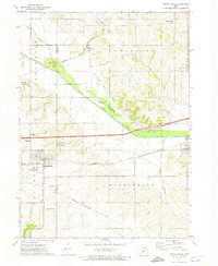
1972 Map of Mitchellville
USGS Topo · Published 1974About this map
Mitchellville sits at the heart of this early 1970s landscape, serving as a hub near the State Training Sch and the Radio Towers (WHO). The topography is defined by the broad floodplain of the South Skunk River, which bisects the quadrangle alongside its Old Channel. This corridor is also a historical transit artery, showing the Chicago and North Western and Chicago Rock Island and Pacific railroads, plus an Old Railroad Grade that speaks to earlier rail alignments. Smaller settlements like Valeria, Santiago, and Oswalt are scattered across the surrounding townships of Franklin, Poweshiek, and Washington. Local family history is preserved in several rural burial grounds, including Sams Cem and McKeever Cem, while the eastern edge transition toward Colfax is marked by a riverside Golf Course and wastewater infrastructure.
Find a feature on this map
44 named features on this map. Tap any name to fly to it.
Don’t see what you’re looking for? This feature index may not catch every label — zoom into the map to look around manually.
Map Details
Editions of this 1972 Mitchellville Map
This is the sole edition of this map. No revisions or reprints were ever made.
Other maps of this area

1930 · Mitchellville
USGS Topo · 1:62,500

1954 · Des Moines
USGS Topo · 1:250,000

1956 · Des Moines
USGS Topo · 1:250,000

1957 · Des Moines
USGS Topo · 1:250,000

1965 · Prairie City
USGS Topo · 1:24,000

1965 · Colfax
USGS Topo · 1:24,000

1969 · Des Moines
USGS Topo · 1:250,000
1972 · Runnells
USGS Topo · 1:24,000
1972 · Altoona
USGS Topo · 1:24,000
1972 · Rising Sun
USGS Topo · 1:24,000