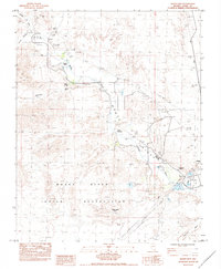
1983 Map of Moapa West
USGS Topo · Published 1984About this map
Moapa River Valley serves as the central artery of this desert landscape, where the Muddy River flows through the Moapa River Indian Reservation. This 1980s-era survey documents the critical infrastructure of the region, anchored by the Union Pacific rail line and a massive network of utilities, including a Power Plant and multiple power lines like the Dbl Wooden Pole Pwr Line.
Find a feature on this map
23 named features on this map. Tap any name to fly to it.
Don’t see what you’re looking for? This feature index may not catch every label — zoom into the map to look around manually.
Map Details
Editions of this 1983 Moapa West Map
This is the sole edition of this map. No revisions or reprints were ever made.
Other maps of this area

1886 · Saint Thomas
USGS Topo · 1:250,000

1893 · Saint Thomas
USGS Topo · 1:250,000

1954 · Las Vegas
USGS Topo · 1:250,000

1957 · Las Vegas
USGS Topo · 1:250,000

1958 · Arrow Canyon
USGS Topo · 1:62,500

1958 · Moapa
USGS Topo · 1:62,500

1959 · Las Vegas
USGS Topo · 1:250,000

1962 · Las Vegas
USGS Topo · 1:250,000

1969 · Farrier
USGS Topo · 1:24,000
1969 · Rox SE
USGS Topo · 1:24,000