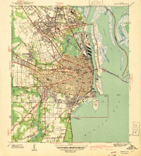
1940 Map of Mobile
USGS Topo · Published 1940About this map
The maritime and industrial activity of Mobile is captured here just before the United States entered World War II, revealing a city defined by its relationship to Mobile Bay and a dense network of rail lines including the Mobile & Ohio RR and Southern Ry. The downtown grid extends from the City Wharf toward suburban expansions like Crichton and Toulminville, while the riverfront is a complex of docks and industries along Blakeley Island and Pinto Island. Cultural and civic landmarks are prominently detailed, from the extensive grounds of Magnolia Cemetery to the Visitation Convent and Murphy High Sch. The map also illustrates early aviation and military history with the Bates Field Airport, the Monroe Park Armory, and the defensive positions of Battery Mc Intosh and Battery Gladden guarding the harbor approaches.
Find a feature on this map
84 named features on this map. Tap any name to fly to it.
Don’t see what you’re looking for? This feature index may not catch every label — zoom into the map to look around manually.
Map Details
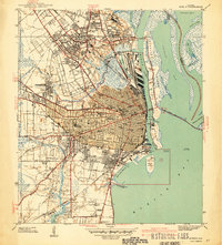
Editions of this 1940 Mobile Map
3 editions found
Other maps of this area

1921 · Fairhope
USGS Topo · 1:62,500

1922 · Mobile
USGS Topo · 1:62,500

1939 · Daphne
USGS Topo · 1:31,680

1940 · Hollingers Island
USGS Topo · 1:31,680

1940 · Mobile
USGS Topo · 1:31,680

1940 · Mobile
USGS Topo · 1:62,500

1941 · Chickasaw
USGS Topo · 1:31,680

1941 · Daphne
USGS Topo · 1:31,680

1941 · Blakeley
USGS Topo · 1:31,680

1941 · Bay Minette
USGS Topo · 1:62,500