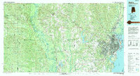
1994 Map of Mobile
USGS Topo · Published 1994About this map
Mobile anchors this coastal landscape where the Mobile River meets the head of Mobile Bay. In the mid-1990s, the city's industrial and maritime footprint is clearly defined, with the USS Alabama Battleship Memorial State Park and Brookley Airport situated along the shoreline. To the west, the rural interior of George and Jackson Counties in Mississippi and Mobile County in Alabama is a dense network of water systems, including the sprawling Big Creek Lake and the meandering Pascagoula River. Extensive protected areas like the Mississippi Sandhill Crane National Wildlife Refuge and the De Soto National Forest dominate the western portion of the sheet. The region's transport evolution is evident in the convergence of the Illinois Central Gulf RR and Louisville and Nashville RR lines near the port, alongside the modern paths of Interstate 65 and Interstate 10.
Find a feature on this map
81 named features on this map. Tap any name to fly to it.
Don’t see what you’re looking for? This feature index may not catch every label — zoom into the map to look around manually.
Map Details
Editions of this 1994 Mobile Map
This is the sole edition of this map. No revisions or reprints were ever made.
Other maps of this area

1921 · Grand Bay
USGS Topo · 1:62,500

1921 · Point Clear
USGS Topo · 1:62,500

1921 · Fairhope
USGS Topo · 1:62,500

1921 · Delchamps
USGS Topo · 1:62,500

1922 · Mobile
USGS Topo · 1:62,500

1939 · Daphne
USGS Topo · 1:31,680

1940 · Hollingers Island
USGS Topo · 1:31,680

1940 · Mobile
USGS Topo · 1:31,680

1940 · Mobile
USGS Topo · 1:62,500

1941 · Chickasaw
USGS Topo · 1:31,680