
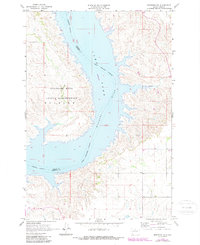
1967 Map of Mobridge NE
USGS Topo · Published 1969About this map
The Oahe Reservoir dominates this mid-1960s landscape, illustrating the controlled inundation of the Missouri River valley along the border of Campbell and Corson Counties. The map reveals the precise Standing Rock Indian Reservation Boundary as it follows the river's original course, bisecting the modern waterway. On the western shore, the undulating terrain of Wakpala rises above the flood zone, while the eastern banks are carved by drainages such as Locke Creek. This survey was conducted just as the reservoir's normal pool elevation of 1596 feet was becoming the defining feature of the regional geography. The presence of fine red dashed lines throughout the uplands indicates field lines and livestock fencing, providing a detailed view of the rural land divisions and agricultural use adjacent to the newly formed lake.
Find a feature on this map
8 named features on this map. Tap any name to fly to it.
Don’t see what you’re looking for? This feature index may not catch every label — zoom into the map to look around manually.
Map Details
Editions of this 1967 Mobridge NE Map
2 editions found
Other maps of this area

1953 · McIntosh
USGS Topo · 1:250,000

1958 · McIntosh
USGS Topo · 1:250,000

1965 · Herreid SW
USGS Topo · 1:24,000

1965 · Pollock SE
USGS Topo · 1:24,000

1966 · Kenel
USGS Topo · 1:24,000

1967 · Glenham
USGS Topo · 1:24,000

1967 · Selby SW
USGS Topo · 1:24,000

1967 · Mobridge NW
USGS Topo · 1:24,000

1967 · Mobridge
USGS Topo · 1:24,000

1967 · Selby NW
USGS Topo · 1:24,000