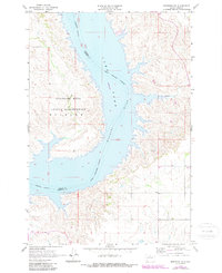
1967 Map of Mobridge NE
USGS Topo · Published 1987About this map
Lake Oahe dominates this landscape, having transformed the Missouri River valley into a massive reservoir by the late 1960s. The water straddles the county line between Campbell Co and Corson Co, with large areas noted as subject to controlled inundation. To the west, the Standing Rock Indian Reservation Mission occupies the high ground above the river’s western shore. This survey provides a distinct record of the reservoir's early footprint, showing how the rising waters redefined the shoreline and influenced the path of local drainages like Locke Creek. The map carefully delineates the Indian Reservation Boundary as it interacts with the newly formed shoreline and internal river channels, marking a period of significant geographical and administrative transition for the Dakotas.
Find a feature on this map
6 named features on this map. Tap any name to fly to it.
Don’t see what you’re looking for? This feature index may not catch every label — zoom into the map to look around manually.
Map Details
Editions of this 1967 Mobridge NE Map
2 editions found
Other maps of this area

1953 · McIntosh
USGS Topo · 1:250,000

1958 · McIntosh
USGS Topo · 1:250,000

1965 · Herreid SW
USGS Topo · 1:24,000

1965 · Pollock SE
USGS Topo · 1:24,000

1966 · Kenel
USGS Topo · 1:24,000

1967 · Glenham
USGS Topo · 1:24,000

1967 · Selby SW
USGS Topo · 1:24,000

1967 · Mobridge NE
USGS Topo · 1:24,000

1967 · Mobridge NW
USGS Topo · 1:24,000

1967 · Mobridge
USGS Topo · 1:24,000