
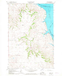
1966 Map of Kenel
USGS Topo · Published 1967About this map
Kenel occupies the high ground overlooking the Oahe Reservoir in this mid-1960s survey of the Standing Rock Indian Reservation. The landscape is characterized by its spiritual and educational hubs, including the St Benedict Ch and the Kenel Sch, while several cemeteries like St Lukes Cem and St Thomas Cem are distributed across the hillsides. The eastern edge of the map is defined by the Missouri River and the flooding of the reservoir, which significantly altered the local topography. This document captures the community structure shortly after the completion of the Oahe Dam project, showing how the local infrastructure, from the Sewage Disposal Pond to the winding course of Blackhawk Creek, adapted to the new shoreline. It serves as a vital record for tracing family sites and tribal land divisions during a period of transition in Corson County.
Find a feature on this map
14 named features on this map. Tap any name to fly to it.
Don’t see what you’re looking for? This feature index may not catch every label — zoom into the map to look around manually.
Map Details
Editions of this 1966 Kenel Map
2 editions found
Other maps of this area

1953 · McIntosh
USGS Topo · 1:250,000

1956 · Wakpala
USGS Topo · 1:24,000

1958 · McIntosh
USGS Topo · 1:250,000

1965 · Pollock SE
USGS Topo · 1:24,000

1965 · Pollock
USGS Topo · 1:24,000

1966 · Mahto NE
USGS Topo · 1:24,000

1966 · Kline Buttes
USGS Topo · 1:24,000

1966 · Pollock NW
USGS Topo · 1:24,000

1967 · Mobridge NE
USGS Topo · 1:24,000

1967 · Mobridge NW
USGS Topo · 1:24,000