
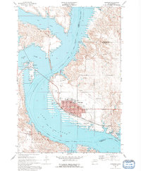
1967 Map of Mobridge
USGS Topo · Published 1969About this map
Mobridge stands as the central hub of this Missouri River landscape, situated where the Chicago Milwaukee St Paul and Pacific railroad crosses the water. The town layout is densely detailed, featuring the Northwestern Lutheran Academy, Hospital, and several schools including Beadle Sch and Davis Sch. The expansion of the Oahe Reservoir dominates the western portion of the map, reshaping the shoreline and historical terrain. Across the water, the Standing Rock Indian Reservation Boundary marks a significant cultural division, encompassing the prominent Sitting Bulls Grave and the Sakakawea Monument on the bluffs overlooking the river. The landscape is a mix of established municipal infrastructure, such as the Mobridge Municipal Airport and Rodeo Arena, and specialized recreation areas like the Indian Memorial Recreation Area and Oahe Hills Country Club. This survey documents a period when the local economy balanced rail transport with the emerging reservoir-based recreational geography.
Find a feature on this map
35 named features on this map. Tap any name to fly to it.
Don’t see what you’re looking for? This feature index may not catch every label — zoom into the map to look around manually.
Map Details
Editions of this 1967 Mobridge Map
2 editions found
Other maps of this area

1953 · McIntosh
USGS Topo · 1:250,000

1956 · Wakpala SE
USGS Topo · 1:24,000

1956 · Wakpala
USGS Topo · 1:24,000

1958 · McIntosh
USGS Topo · 1:250,000

1967 · Glenham
USGS Topo · 1:24,000

1967 · Mobridge NE
USGS Topo · 1:24,000

1967 · Mobridge NW
USGS Topo · 1:24,000

1968 · Moreau NW
USGS Topo · 1:24,000

1968 · Moreau NE
USGS Topo · 1:24,000

1975 · Laundreaux Butte
USGS Topo · 1:24,000