
1956 Map of Wakpala SE
USGS Topo · Published 1957About this map
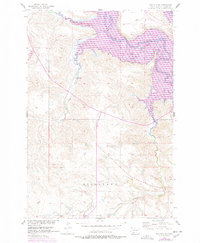
The Grand River winds through the northern portion of this Corson County landscape, carving a wide valley through the expansive Ridgeland of northern South Dakota. This mid-century survey documents the area's vital transportation corridor, dominated by the Chicago Milwaukee St Paul and Pacific railroad as it parallels the river's course. Several seasonal waterways, including Snake Creek and Deep Bank Creek, drain the higher elevations of the plateau into the primary river basin. The map captures the topography of the Missouri River Basin during a period of transition, following the 1950 aerial photography and subsequent field checks that recorded the land prior to significant water management changes. The southern reaches are defined by the winding course of Claymore Creek, illustrating the complex drainage patterns that shaped this prairie environment.
Find a feature on this map
8 named features on this map. Tap any name to fly to it.
Don’t see what you’re looking for? This feature index may not catch every label — zoom into the map to look around manually.
Map Details
Editions of this 1956 Wakpala SE Map
2 editions found
Other maps of this area

1953 · McIntosh
USGS Topo · 1:250,000

1956 · Wakpala NW
USGS Topo · 1:24,000

1956 · Wakpala SW
USGS Topo · 1:24,000

1956 · Wakpala
USGS Topo · 1:24,000

1958 · McIntosh
USGS Topo · 1:250,000

1967 · Mobridge NW
USGS Topo · 1:24,000

1967 · Mobridge
USGS Topo · 1:24,000

1968 · Moreau NW
USGS Topo · 1:24,000

1975 · Laundreaux Butte
USGS Topo · 1:24,000

1975 · Trail City
USGS Topo · 1:24,000