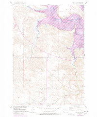
1956 Map of Wakpala SE
USGS Topo · Published 1978About this map
Lake Oahe dominates the northeastern landscape of this Corson County survey, representing a significant era of transformation within the Standing Rock Indian Reservation. The map documentation, updated in the late 1970s, illustrates the inundation caused by the Oahe Dam, which altered the original course of the Grand River and its surrounding bottomlands. The Chicago Milwaukee St Paul and Pacific railroad line is shown traversing the northern reaches, crossing the water as it follows the drainage of Deep Bank Creek. To the south, the terrain rises significantly toward Mission Ridge, a prominent upland area that separates the river basin from the southern drainages of Snake Creek and Claymore Creek. This 1:24,000 scale study provides an essential look at the geography of the Missouri River Basin development program, balancing the original 1956 field checks with the post-reservoir landscape of the 1970s.
Find a feature on this map
9 named features on this map. Tap any name to fly to it.
Don’t see what you’re looking for? This feature index may not catch every label — zoom into the map to look around manually.
Map Details
Editions of this 1956 Wakpala SE Map
2 editions found
Other maps of this area

1953 · McIntosh
USGS Topo · 1:250,000

1956 · Wakpala NW
USGS Topo · 1:24,000

1956 · Wakpala SE
USGS Topo · 1:24,000

1956 · Wakpala SW
USGS Topo · 1:24,000

1956 · Wakpala
USGS Topo · 1:24,000

1958 · McIntosh
USGS Topo · 1:250,000

1967 · Mobridge NW
USGS Topo · 1:24,000

1967 · Mobridge
USGS Topo · 1:24,000

1968 · Moreau NW
USGS Topo · 1:24,000

1975 · Laundreaux Butte
USGS Topo · 1:24,000