1970 Map of Moccasin
USGS Topo · Published 1973About this map
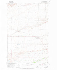
Moccasin serves as a focal point in this Central Montana landscape, situated along the Burlington Northern railroad corridor. The area is defined by a blend of agricultural research and hydraulic engineering, most notably at the Agriculture Experimental Sta west of town and the Murray Ditch irrigation works to the south. The terrain is cut by several seasonal drainages including Squaw Coulee and Louse Creek, eventually giving way to the Judith River near Hobson. This 1970s survey illustrates a rural economy deeply tied to the land and rail, where a local Cem and scattered Gravel Pits mark the modest human footprint on the Judith Basin plains.
Find a feature on this map
13 named features on this map. Tap any name to fly to it.
Don’t see what you’re looking for? This feature index may not catch every label — zoom into the map to look around manually.
Map Details
Editions of this 1970 Moccasin Map
This is the sole edition of this map. No revisions or reprints were ever made.
Other maps of this area

1886 · Little Belt Mts.
USGS Topo · 1:250,000

1889 · Big Snowy Mountain
USGS Topo · 1:250,000

1890 · Fort Benton
USGS Topo · 1:250,000

1892 · Fort Benton
USGS Topo · 1:250,000

1893 · Big Snowy Mountain
USGS Topo · 1:250,000

1894 · Little Belt Mts.
USGS Topo · 1:250,000

1897 · Fort Benton
USGS Topo · 1:250,000

1897 · Little Belt Mts.
USGS Topo · 1:250,000

1898 · Little Belt Mts.
USGS Topo · 1:250,000

1902 · Little Belt Mts.
USGS Topo · 1:250,000