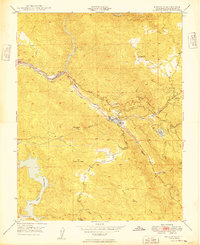
1949 Map of Moccasin
USGS Topo · Published 1949About this map
Jacksonville and the canyon of the Tuolumne River define this 1949 topographic study of Tuolumne County. This era captures the critical infrastructure of the Hetch Hetchy system, including the Hetch Hetchy Aqueduct and the Inclined Railroad near the Moccasin settlement. The map serves as a vital record for mining history, pinpointing operations like the Harriman Mine, Clio Mine, and McAlpine Mine before further 20th-century landscape changes.
Find a feature on this map
38 named features on this map. Tap any name to fly to it.
Don’t see what you’re looking for? This feature index may not catch every label — zoom into the map to look around manually.
Map Details
Editions of this 1949 Moccasin Map
This is the sole edition of this map. No revisions or reprints were ever made.
Other maps of this area

1893 · Sonora
USGS Topo · 1:125,000

1896 · Sonora
USGS Topo · 1:125,000

1897 · Sonora
USGS Topo · 1:125,000

1898 · Sonora
USGS Topo · 1:125,000

1915 · La Grange
USGS Topo · 1:24,000

1919 · La Grange
USGS Topo · 1:31,680

1944 · Merced Falls
USGS Topo · 1:62,500

1947 · San Jose
USGS Topo · 1:250,000

1947 · Coulterville
USGS Topo · 1:62,500
1947 · Chinese Camp
USGS Topo · 1:24,000