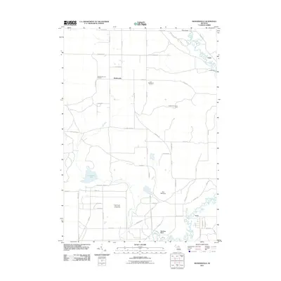
2011 Map of Moddersville
USGS Topo · Published 2011About this map
Moddersville and the surrounding rural landscape in Missaukee County are defined by the winding course of the Muskegon River and its northern tributaries. The area maintains a quiet, agricultural and timber-focused character, marked by essential community landmarks like the West Moddersville Cemetery and East Moddersville Cemetery. Industrial land use is evident at the Cranberry Lake Oil and Gas Storage Field, situated near the headwaters of Cranberry Creek. To the east, the settlement of Leota sits near a complex bend in the river, while the Moddersville Lookout Tower on Blue Mountain provides a vantage point over the low-lying wetlands of Cranberry Lake. The map details a network of rural roads such as E Falmouth Rd and S McVety Rd that connect isolated farmsteads and riverside settlements like Dolph.
Find a feature on this map
57 named features on this map. Tap any name to fly to it.
Don’t see what you’re looking for? This feature index may not catch every label — zoom into the map to look around manually.
Map Details
Editions of this 2011 Moddersville Map
This is the sole edition of this map. No revisions or reprints were ever made.
Other maps of this area

1954 · Traverse City
USGS Topo · 1:250,000

1956 · Houghton Lake
USGS Topo · 1:62,500

1956 · Lake City
USGS Topo · 1:62,500

1957 · Harrison
USGS Topo · 1:62,500

1957 · Marion
USGS Topo · 1:62,500

1958 · Traverse City
USGS Topo · 1:250,000

1983 · Cadillac
USGS Topo · 1:100,000
1983 · Temple
USGS Topo · 1:25,000

1983 · Moddersville
USGS Topo · 1:25,000
1983 · Dinca
USGS Topo · 1:25,000