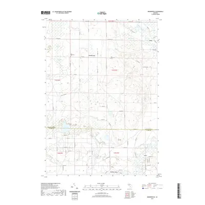
2019 Map of Moddersville
USGS Topo · Published 2019About this map
Moddersville and the surrounding wetlands of Holland Township define this 2019 survey, which captures a landscape heavily influenced by the meandering Muskegon River. The map provides excellent detail for genealogists, clearly marking both the West Moddersville Cem and East Moddersville Cem, which anchor the local community. The terrain is characterized by an extensive network of marshes and swamps, including Spitzbergen Marsh, Ralyea Marsh, and Luttrell Marsh, interspersed with higher points like Blue Mtn.
Find a feature on this map
73 named features on this map. Tap any name to fly to it.
Don’t see what you’re looking for? This feature index may not catch every label — zoom into the map to look around manually.
Map Details
Editions of this 2019 Moddersville Map
This is the sole edition of this map. No revisions or reprints were ever made.
Other maps of this area

1954 · Traverse City
USGS Topo · 1:250,000

1956 · Houghton Lake
USGS Topo · 1:62,500

1956 · Lake City
USGS Topo · 1:62,500

1957 · Harrison
USGS Topo · 1:62,500

1957 · Marion
USGS Topo · 1:62,500

1958 · Traverse City
USGS Topo · 1:250,000

1983 · Cadillac
USGS Topo · 1:100,000
1983 · Temple
USGS Topo · 1:25,000

1983 · Moddersville
USGS Topo · 1:25,000
1983 · Dinca
USGS Topo · 1:25,000