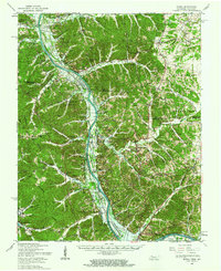
1957 Map of Model
USGS Topo · Published 1963About this map
The Cumberland River flows through the heart of this landscape during a period of massive hydrological change. While the Tennessee River to the west has already formed Kentucky Lake, the Cumberland is in the midst of its own transformation with Lake Barkley under construction. This transition is documented at a moment when traditional river landings and small agricultural centers like Tobaccoport and Bumpus Mills still define the local geography.
Find a feature on this map
84 named features on this map. Tap any name to fly to it.
Don’t see what you’re looking for? This feature index may not catch every label — zoom into the map to look around manually.
Map Details
Editions of this 1957 Model Map
This is the sole edition of this map. No revisions or reprints were ever made.
Other maps of this area

1931 · Erin
USGS Topo · 1:62,500

1936 · Tharpe
USGS Topo · 1:24,000

1936 · Hamlin
USGS Topo · 1:24,000

1936 · Fenton
USGS Topo · 1:24,000

1936 · Centerville Landing
USGS Topo · 1:24,000

1936 · Golden Pond
USGS Topo · 1:48,000

1936 · Rushing
USGS Topo · 1:24,000

1936 · Standing Rock
USGS Topo · 1:24,000

1936 · Dover
USGS Topo · 1:24,000

1950 · Rushing Creek
USGS Topo · 1:24,000