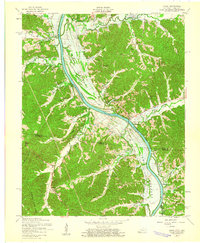
1957 Map of Model
USGS Topo · Published 1960About this map
The Cumberland River corridor undergoes a massive transformation on this mid-century survey as Lake Barkley forms behind a dam under construction. This map documents the river valley just before the rising waters permanently altered the landscape between the Kentucky-Tennessee border. Notable settlements like Linton and Donaldson sit near the river's edge, while smaller communities such as Shelby Spring and the curious river-adjacent Tobacconport are shown in their original locations.
Find a feature on this map
46 named features on this map. Tap any name to fly to it.
Don’t see what you’re looking for? This feature index may not catch every label — zoom into the map to look around manually.
Map Details
Editions of this 1957 Model Map
This is the sole edition of this map. No revisions or reprints were ever made.
Other maps of this area

1936 · Tharpe
USGS Topo · 1:24,000

1936 · Hamlin
USGS Topo · 1:24,000

1936 · Fenton
USGS Topo · 1:24,000

1936 · Golden Pond
USGS Topo · 1:48,000

1936 · Rushing
USGS Topo · 1:24,000

1950 · Rushing Creek
USGS Topo · 1:24,000
1950 · Fenton
USGS Topo · 1:24,000
1950 · Hamlin
USGS Topo · 1:24,000

1951 · Model
USGS Topo · 1:24,000

1951 · Johnson Hollow
USGS Topo · 1:24,000