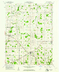
1960 Map of Modoc
USGS Topo · Published 1961About this map
The intersections of the Chesapeake and Ohio and the New York Central railroads anchor this rural Randolph County landscape at the start of the 1960s. The village of Modoc stands as a primary junction in the east, while Bronson, also known by its Losantville post office designation, serves the central territory. The map reveals a high density of small community landmarks, including Modoc Bethel Ch, Mt Zion Ch, and the Township Sch, illustrating the dispersed yet organized settlement pattern of the era. The terrain is defined by the headwaters of several drainages, such as Stoney Creek and Nettle Creek, which meander through a grid of numbered section roads. Local history is further preserved through numerous small burial grounds like Little Creek Cem and Scott Cem, marking the early family plots and churchyards that defined these Indiana townships.
Find a feature on this map
45 named features on this map. Tap any name to fly to it.
Don’t see what you’re looking for? This feature index may not catch every label — zoom into the map to look around manually.
Map Details
Editions of this 1960 Modoc Map
This is the sole edition of this map. No revisions or reprints were ever made.
Other maps of this area

1950 · New Castle East
USGS Topo · 1:24,000

1952 · Maxville
USGS Topo · 1:24,000

1952 · Muncie East
USGS Topo · 1:24,000

1952 · Farmland
USGS Topo · 1:24,000

1953 · Cincinnati
USGS Topo · 1:250,000

1953 · Muncie
USGS Topo · 1:250,000

1956 · Muncie
USGS Topo · 1:250,000

1957 · Cincinnati
USGS Topo · 1:250,000

1960 · New Castle East
USGS Topo · 1:24,000

1960 · Mount Pleasant
USGS Topo · 1:24,000