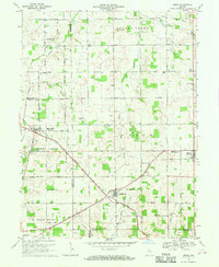
1969 Map of Modoc
USGS Topo · Published 1970About this map
Losantville and Modoc serve as primary hubs in this East Central Indiana landscape, where the Chesapeake and Ohio and Penn Central rail lines converge. The rural character of the region is defined by a dense network of county roads, such as 800 North Road and 600 South Road, connecting numerous community anchors including Union Ch, Mt Zion Ch, and the Township Sch.
Find a feature on this map
52 named features on this map. Tap any name to fly to it.
Don’t see what you’re looking for? This feature index may not catch every label — zoom into the map to look around manually.
Map Details
Editions of this 1969 Modoc Map
This is the sole edition of this map. No revisions or reprints were ever made.
Other maps of this area
1950 · New Castle East
USGS Topo · 1:24,000
1952 · Maxville
USGS Topo · 1:24,000
1952 · Muncie East
USGS Topo · 1:24,000
1952 · Farmland
USGS Topo · 1:24,000

1953 · Cincinnati
USGS Topo · 1:250,000

1953 · Muncie
USGS Topo · 1:250,000

1956 · Muncie
USGS Topo · 1:250,000

1957 · Cincinnati
USGS Topo · 1:250,000
1960 · New Castle East
USGS Topo · 1:24,000
1960 · Mount Pleasant
USGS Topo · 1:24,000