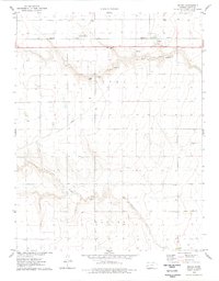
1976 Map of Modoc
USGS Topo · Published 1978About this map
The unincorporated settlement of Modoc stands as a focal point in this 1970s western Kansas landscape, situated along the Missouri Pacific railroad. The map documents the rural infrastructure of Scott County, where the high plains are dissected by the drainage of Lion Creek and the meandering Rocky Draw. Local history is anchored by the Modoc Cem, while the economic activity of the era is represented by several instances of Gravel Pit and large-scale Feedlot operations near the tracks. The topography reveals the subtle but significant depression of the Isbel Valley, providing a detailed look at the section lines and farmstead placements that define the regional grid. This survey serves as a clear record of the area's agricultural and transit-oriented layout before later shifts in rail usage and land management changed the character of these small prairie outposts.
Find a feature on this map
10 named features on this map. Tap any name to fly to it.
Don’t see what you’re looking for? This feature index may not catch every label — zoom into the map to look around manually.
Map Details
Editions of this 1976 Modoc Map
This is the sole edition of this map. No revisions or reprints were ever made.
Other maps of this area

1939 · Sandon
USGS Topo · 1:62,500

1939 · Pence
USGS Topo · 1:62,500

1940 · Scott City
USGS Topo · 1:62,500

1941 · Modoc
USGS Topo · 1:62,500

1941 · Pence
USGS Topo · 1:62,500

1942 · Sandon
USGS Topo · 1:62,500

1951 · Scott City
USGS Topo · 1:62,500

1951 · Modoc
USGS Topo · 1:62,500

1955 · Scott City
USGS Topo · 1:250,000

1958 · Scott City
USGS Topo · 1:250,000