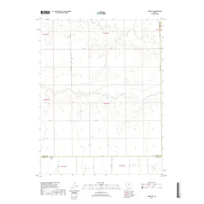
2018 Map of Modoc SW
USGS Topo · Published 2018About this map
Lydia Methodist Cem sits along the southern border of Wichita County, marking a spiritual and genealogical touchstone in this High Plains agricultural landscape. The terrain is defined by the ephemeral drainage patterns of White-Woman Cr and Sand Cr, which cut shallow paths across the township. These seasonal waterways, along with Crozier Draw in the southeast, dictate the subtle relief of the land. A rigid section-line road network, including north-south corridors like Marienthal Rd and Co RD 22, facilitates the movement of grain and machinery between scattered farmsteads. The eastern boundary is delineated by the Wichita-Scott Co Rd, while the southern edge meets the Kearney County line, illustrating the methodical township and range surveying system that shaped western Kansas.
Find a feature on this map
26 named features on this map. Tap any name to fly to it.
Don’t see what you’re looking for? This feature index may not catch every label — zoom into the map to look around manually.
Map Details
Editions of this 2018 Modoc SW Map
This is the sole edition of this map. No revisions or reprints were ever made.
Other maps of this area

1941 · Modoc
USGS Topo · 1:62,500

1951 · Modoc
USGS Topo · 1:62,500

1955 · Scott City
USGS Topo · 1:250,000

1958 · Scott City
USGS Topo · 1:250,000

1965 · Leoti 3 NE
USGS Topo · 1:24,000

1965 · Wolf NW
USGS Topo · 1:24,000

1965 · Wolf NE
USGS Topo · 1:24,000

1970 · Leoti
USGS Topo · 1:24,000

1970 · Lydia
USGS Topo · 1:24,000
1976 · Modoc SW
USGS Topo · 1:24,000