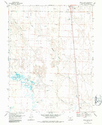
1968 Map of Moffat South
USGS Topo · Published 1987About this map
Saguache Creek and Ball Arroyo weave through this high-altitude basin during the late 1960s, a period when the landscape was defined by an extensive network of groundwater extraction. Numerous Flowing Wells are mapped across the terrain, indicating a high water table and the importance of artesian water for the agricultural interests surrounding the settlement of Moffat. The geography is notably flat, characterized by seasonal drainage patterns and the presence of Mishak Lakes and the small locality of Mishak to the west.
Find a feature on this map
15 named features on this map. Tap any name to fly to it.
Don’t see what you’re looking for? This feature index may not catch every label — zoom into the map to look around manually.
Map Details
Editions of this 1968 Moffat South Map
2 editions found
Other maps of this area

1915 · Del Norte
USGS Topo · 1:125,000

1917 · Del Norte
USGS Topo · 1:125,000

1945 · Durango
USGS Topo · 1:250,000

1953 · Durango
USGS Topo · 1:250,000

1954 · Durango
USGS Topo · 1:250,000

1954 · Trinidad
USGS Topo · 1:250,000

1954 · Pueblo
USGS Topo · 1:250,000

1955 · Trinidad
USGS Topo · 1:250,000

1956 · Montrose
USGS Topo · 1:250,000

1957 · Pueblo
USGS Topo · 1:250,000