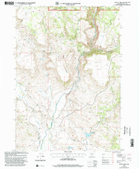
1999 Map of Moffit Table
USGS Topo · Published 2002About this map
The Malheur National Forest dominates this high-desert landscape in Harney County, where the Malheur River carves a deep path through the plateau. This area is defined by its complex hydrology, featuring numerous isolated water sources such as Gully Spring, Seep Spring, and the Big Spring. The terrain rises toward Battle Mountain and the expansive flat top of Moffit Table, illustrating the dramatic volcanic geography of eastern Oregon. Local ranching and water management are evident in the presence of the Griffin Creek Reservoir and Bar S Reservoir, along with a network of irrigation structures simply labeled Ditch. Seasonal drainages like Bluebucket Creek and Coyote Creek further define the land use patterns, while historic routes like Van Drewsey Road and Clark Lane provide the primary access through this sparsely populated interior.
Find a feature on this map
24 named features on this map. Tap any name to fly to it.
Don’t see what you’re looking for? This feature index may not catch every label — zoom into the map to look around manually.
Map Details
Editions of this 1999 Moffit Table Map
This is the sole edition of this map. No revisions or reprints were ever made.
Other maps of this area

1908 · Ironside Mountain
USGS Topo · 1:125,000

1955 · Burns
USGS Topo · 1:250,000

1955 · Canyon City
USGS Topo · 1:250,000

1958 · Burns
USGS Topo · 1:250,000

1959 · Burns
USGS Topo · 1:250,000

1959 · Canyon City
USGS Topo · 1:250,000

1961 · Logan Valley
USGS Topo · 1:62,500

1968 · Drewsey
USGS Topo · 1:62,500

1968 · Van
USGS Topo · 1:62,500

1970 · Flag Prairie
USGS Topo · 1:62,500