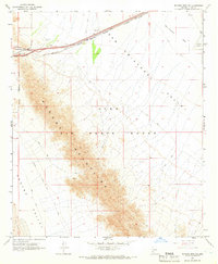
1965 Map of Mohawk Mts NW
USGS Topo · Published 1966About this map
Mohawk Mountains and the arid expanse of the San Cristobal Valley dominate this mid-1960s desert landscape. The corridor through Mohawk Pass serves as a critical infrastructure artery, carrying the Southern Pacific railroad and major highways across the terrain. While the northern section of the map shows industrial activity through several Gravel Pits and a Radio Facility, the central and southern portions are largely defined by the sprawling Luke Air Force Range. Traces of earlier activity appear in the form of a Prospect and Ruins tucked into the mountain slopes, while the eastern edge is marked by the presence of Stoval Airfield. The southern boundary reveals the distinctive shifting landscape of Sand Dune Alley, illustrating the geological diversity of this Yuma County region.
Find a feature on this map
17 named features on this map. Tap any name to fly to it.
Don’t see what you’re looking for? This feature index may not catch every label — zoom into the map to look around manually.
Map Details
Editions of this 1965 Mohawk Mts NW Map
2 editions found
Other maps of this area

1926 · Mohawk
USGS Topo · 1:62,500

1927 · Kim
USGS Topo · 1:62,500

1928 · Mohawk
USGS Topo · 1:62,500

1928 · Norton
USGS Topo · 1:62,500

1929 · Norton
USGS Topo · 1:62,500

1930 · Stoval
USGS Topo · 1:62,500

1931 · Kim
USGS Topo · 1:62,500

1950 · Stoval
USGS Topo · 1:62,500

1953 · Ajo
USGS Topo · 1:250,000

1955 · Growler
USGS Topo · 1:24,000