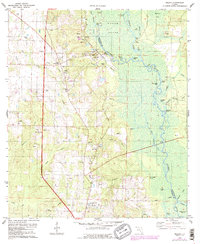
1978 Map of Molino
USGS Topo · Published 1987About this map
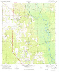
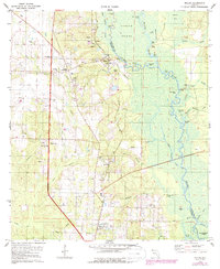
Escambia River bottomlands dominate the eastern half of this landscape, creating a complex network of backwaters and named sloughs like The Basin and Goggleeye Lake. The terrain transitions from these wetlands to the elevated pine woods of the west, where the CSX railroad corridor serves as the spine for community development. The settlement at Molino and its nearby Molino Crossroads are established centers of local life, supported by a dense cluster of rural institutions including the Molino Sch and Highland Ch. The riverfront economy of the late 1970s is evidenced by several river access points such as Webb Landing and Proctors Landing, while the presence of numerous claypits across the central hills suggests a landscape shaped by local extraction. Genealogists will find significant value in the documentation of family-named landmarks and resting places like Barrineau Cem and Vaughn Cem, situated among the winding drainages of Jacks Branch and Wilder Branch.
Find a feature on this map
63 named features on this map. Tap any name to fly to it.
Don’t see what you’re looking for? This feature index may not catch every label — zoom into the map to look around manually.
Map Details
Editions of this 1978 Molino Map
3 editions found
Other maps of this area

1920 · Milton
USGS Topo · 1:62,500

1921 · Muscogee
USGS Topo · 1:62,500

1941 · Muscogee
USGS Topo · 1:62,500

1941 · Milton
USGS Topo · 1:62,500

1941 · Century
USGS Topo · 1:62,500

1943 · Muscogee
USGS Topo · 1:62,500

1943 · Century
USGS Topo · 1:62,500

1943 · Milton
USGS Topo · 1:62,500

1943 · Jay
USGS Topo · 1:62,500
1944 · Floridatown
USGS Topo · 1:25,000