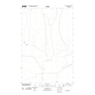
2011 Map of Monarch NE
USGS Topo · Published 2011About this map
Monarch Cemetery sits in the southeastern reaches of this high-plains landscape, serving as a primary point of interest for genealogists tracing family roots in Cascade County. The terrain is defined by dramatic geological features, including the prominent rise of Rattlesnake Butte and the deep incision of Goodman Coulee. This 2011 survey documents a network of rural routes that follow the natural contours of the land, such as Brigham Coulee Rd and Limestone Butte Rd. These roads reflect the enduring ranching and agricultural patterns of central Montana, where even minor thoroughfares like Never Sweat Ln and Oriet Rd provide essential access through the undulating coulee country. The map captures a moment of modern continuity in a sparsely populated region where the names of ridges and drainages remain the primary markers of location and history.
Find a feature on this map
7 named features on this map. Tap any name to fly to it.
Don’t see what you’re looking for? This feature index may not catch every label — zoom into the map to look around manually.
Map Details
Editions of this 2011 Monarch NE Map
This is the sole edition of this map. No revisions or reprints were ever made.
Other maps of this area

1890 · Fort Benton
USGS Topo · 1:250,000

1892 · Fort Benton
USGS Topo · 1:250,000

1897 · Fort Benton
USGS Topo · 1:250,000

1954 · Great Falls
USGS Topo · 1:250,000

1956 · Belt
USGS Topo · 1:62,500

1957 · Great Falls
USGS Topo · 1:250,000
1961 · Limestone Butte
USGS Topo · 1:24,000
1961 · Barker
USGS Topo · 1:24,000

1961 · Barker
USGS Topo · 1:62,500
1967 · Monarch NE
USGS Topo · 1:24,000