
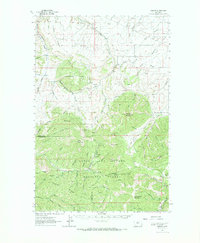
1961 Map of Barker
USGS Topo · Published 1966About this map
Barker and Hughesville sit at the heart of this mountain survey, marking a landscape defined by its mining heritage and high peaks. Situated within the Lewis and Clark National Forest, the region is characterized by steep drainages like Big Otter Creek and Little Canyon Creek that cut through the limestone terrain. The presence of the Chambers Mine, Noller Mine, and several unnamed mines near Barker Mountain point to the area's industrial past, where prospectors sought minerals in the shadows of Clendennin Mountain and Mixes Baldy. Local history is anchored by the Barker Cem, while surveyors recorded the heights of prominent landmarks such as Limestone Butte and Irene Peak. A network of Jeep Trails and Pack Trails indicates how the rugged interior remained accessible to those working the land in the early 1960s.
Find a feature on this map
93 named features on this map. Tap any name to fly to it.
Don’t see what you’re looking for? This feature index may not catch every label — zoom into the map to look around manually.
Map Details
Editions of this 1961 Barker Map
2 editions found
Other maps of this area

1886 · Little Belt Mts.
USGS Topo · 1:250,000

1890 · Fort Benton
USGS Topo · 1:250,000

1892 · Fort Benton
USGS Topo · 1:250,000

1894 · Little Belt Mts.
USGS Topo · 1:250,000

1897 · Fort Benton
USGS Topo · 1:250,000

1897 · Little Belt Mts.
USGS Topo · 1:250,000

1898 · Little Belt Mts.
USGS Topo · 1:250,000

1902 · Little Belt Mts.
USGS Topo · 1:250,000

1948 · White Sulphur Springs
USGS Topo · 1:250,000

1954 · Great Falls
USGS Topo · 1:250,000