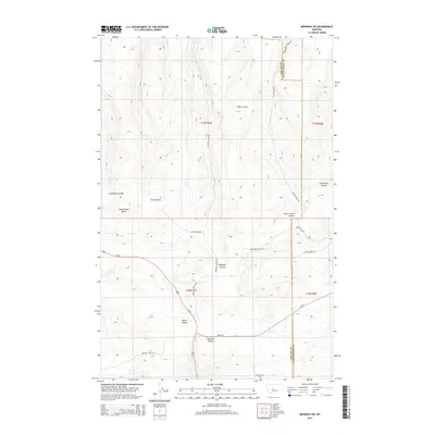
2014 Map of Monarch NE
USGS Topo · Published 2014About this map
The boundary between Cascade County and Judith Basin County cuts through this high-elevation terrain, where deep drainage channels define the rural landscape. In the southern portion of the quadrangle, the Monarch Cem sits near the entrance to Monarch Canyon, a significant topographical break where Us-89 winds through the hills. The area is marked by a complex network of named coulees, including Swan Coulee, Ford Coulee, and Never Sweat Coulee, which suggest a long history of ranching and land management in this part of Montana. Prominent landforms such as Rattlesnake Butte overlook the winding paths of Brigman Coulee Rd and Limestone Butte Rd, reflecting the remote and topographical character of the Little Belt Mountains region.
Find a feature on this map
25 named features on this map. Tap any name to fly to it.
Don’t see what you’re looking for? This feature index may not catch every label — zoom into the map to look around manually.
Map Details
Editions of this 2014 Monarch NE Map
This is the sole edition of this map. No revisions or reprints were ever made.
Other maps of this area

1890 · Fort Benton
USGS Topo · 1:250,000

1892 · Fort Benton
USGS Topo · 1:250,000

1897 · Fort Benton
USGS Topo · 1:250,000

1954 · Great Falls
USGS Topo · 1:250,000

1956 · Belt
USGS Topo · 1:62,500

1957 · Great Falls
USGS Topo · 1:250,000
1961 · Limestone Butte
USGS Topo · 1:24,000
1961 · Barker
USGS Topo · 1:24,000

1961 · Barker
USGS Topo · 1:62,500
1967 · Monarch NE
USGS Topo · 1:24,000