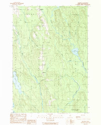
1989 Map of Monarda
USGS Topo · Published 1989About this map
Silver Ridge anchors this late-twentieth-century survey of southern Aroostook County, where the settlement of Monarda sits along a north-south ridge line. The landscape is defined by a dense network of waterways and timberlands, with Molunkus Stream and Macwahoc Stream draining the varied terrain. In the west, Plunkett Pond and Flinn Pond flank the boundary near Benedicta, while the northeast is dominated by Macwahoc Lake and Lower Macwahoc Lake. The map illustrates the traditional survey township divisions typical of Northern Maine, including T 3 R 4 Wels and Upper Molunkus. Aside from the small clusters at Woodbridge Corner and the primary ridge, the area remains largely characterized by its brooks and streams, such as Logan Brook and Gulliver Brook, reflecting a region tied closely to its natural resources and limited road network.
Find a feature on this map
29 named features on this map. Tap any name to fly to it.
Don’t see what you’re looking for? This feature index may not catch every label — zoom into the map to look around manually.
Map Details
Editions of this 1989 Monarda Map
This is the sole edition of this map. No revisions or reprints were ever made.
Other maps of this area

1940 · Sherman
USGS Topo · 1:62,500

1940 · Mattawamkeag
USGS Topo · 1:62,500

1941 · Mattawamkeag Lake
USGS Topo · 1:62,500

1941 · Wytopitlock
USGS Topo · 1:62,500

1942 · Mattawamkeag
USGS Topo · 1:62,500

1942 · Sherman
USGS Topo · 1:62,500

1943 · Wytopitlock
USGS Topo · 1:62,500

1943 · Mattawamkeag Lake
USGS Topo · 1:62,500

1954 · Millinocket
USGS Topo · 1:250,000

1958 · Millinocket
USGS Topo · 1:250,000