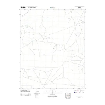
2010 Map of Moncisco Wash
USGS Topo · Published 2010About this map
The Bisti Oil Field defines much of this desert landscape within the Eastern Navajo Agency, showing the extensive network of access roads and infrastructure required for resource extraction in the early 21st century. To the west, the prominent elevation of Moncisco Mesa overlooks a terrain cut by seasonal drainage systems, most notably the Moncisco Wash which meanders across the northern half of the sheet. Evidence of the region's sparse water resources is found at Jeters Lake, while the eastern portion of the quadrangle is marked by the deep incision of the West Fork Gallegos Canyon. Transportation through this arid expanse relies on a series of numbered routes, including Road 7100 and Indian Service Route 53, which connect the oil-producing zones to the surrounding high desert plateau and the southern slope of Black Hill.
Find a feature on this map
9 named features on this map. Tap any name to fly to it.
Don’t see what you’re looking for? This feature index may not catch every label — zoom into the map to look around manually.
Map Details
Editions of this 2010 Moncisco Wash Map
This is the sole edition of this map. No revisions or reprints were ever made.
Other maps of this area

1889 · Chaco
USGS Topo · 1:250,000

1892 · Chaco
USGS Topo · 1:250,000

1927 · Sulphur Spring
USGS Topo · 1:96,000

1928 · Kirtland
USGS Topo · 1:125,000

1932 · Kirtland
USGS Topo · 1:125,000

1954 · Shiprock
USGS Topo · 1:250,000

1958 · Shiprock
USGS Topo · 1:250,000

1959 · Shiprock
USGS Topo · 1:250,000
1965 · Gallegos Trading Post
USGS Topo · 1:24,000
1965 · Hugh Lake
USGS Topo · 1:24,000