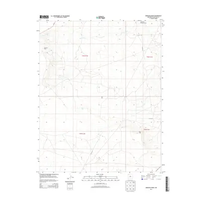
2013 Map of Moncisco Wash
USGS Topo · Published 2013About this map
Bisti Oil Field defines much of this high-desert landscape in the Eastern Navajo Agency, where the industrial infrastructure of energy extraction meets the natural drainage systems of San Juan County. The terrain is marked by the prominent Moncisco Mesa and the drainage of Moncisco Wash, which cuts across the northwest. While largely an arid region, the presence of Jeters Lake and the West Fork Gallegos Canyon provide localized points of geographic interest in an area otherwise dominated by the geometric patterns of oil and gas development. Modern utility and transport networks are evident through labels for the Pipe Line Rd and Pipe Yard Rd, which support the field operations, alongside more established routes like NM-371 and Indian Service Route 5. This survey reflects the 21st-century character of the San Juan Basin as a hub of energy production within the Navajo Nation.
Find a feature on this map
16 named features on this map. Tap any name to fly to it.
Don’t see what you’re looking for? This feature index may not catch every label — zoom into the map to look around manually.
Map Details
Editions of this 2013 Moncisco Wash Map
This is the sole edition of this map. No revisions or reprints were ever made.
Other maps of this area

1889 · Chaco
USGS Topo · 1:250,000

1892 · Chaco
USGS Topo · 1:250,000

1927 · Sulphur Spring
USGS Topo · 1:96,000

1928 · Kirtland
USGS Topo · 1:125,000

1932 · Kirtland
USGS Topo · 1:125,000

1954 · Shiprock
USGS Topo · 1:250,000

1958 · Shiprock
USGS Topo · 1:250,000

1959 · Shiprock
USGS Topo · 1:250,000
1965 · Gallegos Trading Post
USGS Topo · 1:24,000
1965 · Hugh Lake
USGS Topo · 1:24,000