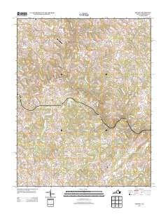
2013 Map of Moneta
USGS Topo · Published 2013About this map
Davis Mill and Moneta anchor this portion of Bedford County, where a network of creeks and small runs feed into the larger Goose Cr system. The topography is defined by significant rises like Stone Mountain and the low-lying basin of Dark Hollow, illustrating the varied landscape of south-central Virginia. The presence of Prison Camp Number 24 and Fox Field Airport indicates the diverse land use in the area, ranging from institutional to aviation-related infrastructure. Water features such as Spring Lake and Sounders Pond are scattered throughout the quadrangle, connected by various branches like Bold Br and Creasey Mill Cr. Local transport is facilitated by rural routes that intersect at The Meadows of Goose Creek, while Haden Bridge provides a notable crossing over the local waterways. The map preserves a detailed look at the rural road network and named geographic features that define this community.
Find a feature on this map
100 named features on this map. Tap any name to fly to it.
Don’t see what you’re looking for? This feature index may not catch every label — zoom into the map to look around manually.
Map Details
Editions of this 2013 Moneta Map
This is the sole edition of this map. No revisions or reprints were ever made.
Other maps of this area

1890 · Roanoke
USGS Topo · 1:125,000

1891 · Roanoke
USGS Topo · 1:125,000

1892 · Lynchburg
USGS Topo · 1:125,000

1947 · Roanoke
USGS Topo · 1:250,000

1950 · Goode
USGS Topo · 1:62,500

1950 · Peaks of Otter
USGS Topo · 1:62,500

1951 · Moneta
USGS Topo · 1:62,500

1951 · Altavista
USGS Topo · 1:62,500

1959 · Roanoke
USGS Topo · 1:250,000

1963 · Roanoke
USGS Topo · 1:250,000