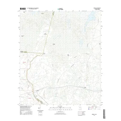
2017 Map of Moniac
USGS Topo · Published 2017About this map
Moniac and Baxter sit along the border of Georgia and Florida, serving as small outposts near the vast Okefenokee Swamp as mapped in 2017. The North Prong Saint Marys River carves the boundary between the states, with the historic marker of Ellicotts Mound positioned where the line breaks north. This landscape is defined by its transition from the deep wetlands of the swamp to the slightly elevated terrain of Trail Ridge. Throughout the region, large bays and islands such as Roasting Ear Island and Brandy Bay emerge from the saturated environment, interconnected by a network of drainage channels like Joaquin Cr and the River Styx. Local history is anchored at the Moniac Cem, while the interior remains defined by distinct breaks in the swamp floor, including Okefenokee Break and Horse Shoe Break.
Find a feature on this map
37 named features on this map. Tap any name to fly to it.
Don’t see what you’re looking for? This feature index may not catch every label — zoom into the map to look around manually.
Map Details
Editions of this 2017 Moniac Map
This is the sole edition of this map. No revisions or reprints were ever made.
Other maps of this area

1917 · Macclenny
USGS Topo · 1:62,500

1918 · Moniac
USGS Topo · 1:62,500

1918 · Macclenny
USGS Topo · 1:62,500

1942 · Moniac
USGS Topo · 1:62,500

1954 · Valdosta
USGS Topo · 1:250,000

1956 · Eddy
USGS Topo · 1:24,000

1958 · Valdosta
USGS Topo · 1:250,000

1959 · Valdosta
USGS Topo · 1:250,000

1965 · Chesser Island
USGS Topo · 1:24,000

1965 · Blackjack Island
USGS Topo · 1:24,000