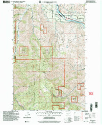
2003 Map of Monitor
USGS Topo · Published 2006About this map
Monitor serves as the focal point of this 2003 survey, situated where the Wenatchee River bends through the valley. The settlement is a junction for local transit, including the Burlington Northern Santa Fe railway and several local routes like Old Monitor Road and Easy St. The surrounding landscape is defined by deep drainage systems such as Yaksum Canyon, Fairview Canyon, and Number One Canyon, which carve through the high ground leading toward Horse Lake Mountain. Large portions of the terrain are managed as part of the Wenatchee National Forest, which borders private lands and the riverside Wenatchee County Park. This map reveals a complex interface between agricultural valley floors, riparian corridors along Mission Creek, and the upland basins and gulches that characterize this part of Chelan County.
Find a feature on this map
30 named features on this map. Tap any name to fly to it.
Don’t see what you’re looking for? This feature index may not catch every label — zoom into the map to look around manually.
Map Details
Editions of this 2003 Monitor Map
This is the sole edition of this map. No revisions or reprints were ever made.
Other maps of this area

1897 · Mount Stuart
USGS Topo · 1:125,000

1901 · Chelan
USGS Topo · 1:125,000

1901 · Chiwaukum
USGS Topo · 1:125,000

1902 · Mount Stuart
USGS Topo · 1:125,000

1904 · Chiwaukum
USGS Topo · 1:125,000

1913 · Wenatchee
USGS Topo · 1:62,500

1915 · Wenatchee
USGS Topo · 1:62,500

1920 · Colockum Pass
USGS Topo · 1:125,000

1922 · Colockum Pass
USGS Topo · 1:125,000

1957 · Wenatchee
USGS Topo · 1:250,000