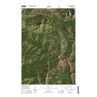
2017 Map of Monitor Peak
USGS Topo · Published 2017About this map
The high peaks of the Absaroka Range dominate this northern Montana landscape, defined by steep relief and a complex network of drainage basins. Monitor Peak and Sliding Mtn stand as prominent landmarks overlooking the deeply carved valleys of Emigrant Gulch and Huckleberry Gulch. Water is central to the topography, with numerous tributaries such as Sixmile Cr, Cedar Cr, and Placer Basin Cr descending from the heights of the Gallatin National Forest. The presence of Fish Lake in the southeast corner provides a rare alpine water body amidst the high-altitude terrain. Human access is limited primarily to the Six Mile Creek Rd in the northwest, suggesting a largely undeveloped wilderness used for resource management and recreation during this period of the twenty-first century.
Find a feature on this map
34 named features on this map. Tap any name to fly to it.
Don’t see what you’re looking for? This feature index may not catch every label — zoom into the map to look around manually.
Map Details
Editions of this 2017 Monitor Peak Map
This is the sole edition of this map. No revisions or reprints were ever made.
Other maps of this area

1891 · Livingston
USGS Topo · 1:250,000

1893 · Livingston
USGS Topo · 1:250,000

1947 · Bozeman
USGS Topo · 1:250,000

1948 · Bozeman
USGS Topo · 1:250,000

1955 · Bozeman
USGS Topo · 1:250,000

1955 · Emigrant
USGS Topo · 1:62,500

1955 · Fridley Peak
USGS Topo · 1:62,500
1955 · Gardiner
USGS Topo · 1:62,500
1955 · Miner
USGS Topo · 1:62,500

1958 · Bozeman
USGS Topo · 1:250,000