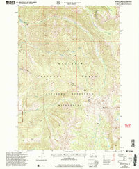
2000 Map of Monitor Peak
USGS Topo · Published 2005About this map
Absaroka Beartooth Wilderness lands define this high-altitude topography, where drainage patterns flow through a series of steep drainages toward the Yellowstone River valley. The terrain is marked by significant elevation changes, rising to the summit of Monitor Peak and the slopes of Sliding Mountain. Water features dominate the local nomenclature, including the alpine Fish Lake and numerous tributary systems like Placer Basin Creek and North Fork Sixmile Creek.
Find a feature on this map
17 named features on this map. Tap any name to fly to it.
Don’t see what you’re looking for? This feature index may not catch every label — zoom into the map to look around manually.
Map Details
Editions of this 2000 Monitor Peak Map
This is the sole edition of this map. No revisions or reprints were ever made.
Other maps of this area

1891 · Livingston
USGS Topo · 1:250,000

1893 · Livingston
USGS Topo · 1:250,000

1947 · Bozeman
USGS Topo · 1:250,000

1948 · Bozeman
USGS Topo · 1:250,000

1955 · Bozeman
USGS Topo · 1:250,000

1955 · Emigrant
USGS Topo · 1:62,500

1955 · Fridley Peak
USGS Topo · 1:62,500
1955 · Gardiner
USGS Topo · 1:62,500
1955 · Miner
USGS Topo · 1:62,500

1958 · Bozeman
USGS Topo · 1:250,000