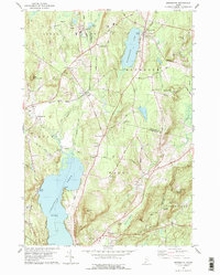
1979 Map of Monmouth
USGS Topo · Published 1979About this map
The Central Maine Railroad cuts through the rural landscape of Androscoggin and Kennebec Counties, connecting the small settlements of Leeds Junction and Monmouth. This 1970s survey captures a transition point in central Maine, where an old railroad grade near Sabattus Pond hints at former transportation corridors, while the University of Maine Agriculture Station reflects the area's continued focus on land management. The terrain is defined by a series of prominent rises such as Sabattus Mtn, Norris Hill, and Prescott Hill, which overlook a network of water bodies including Cochnewagon Lake and Island Pond.
Find a feature on this map
75 named features on this map. Tap any name to fly to it.
Don’t see what you’re looking for? This feature index may not catch every label — zoom into the map to look around manually.
Map Details
Editions of this 1979 Monmouth Map
This is the sole edition of this map. No revisions or reprints were ever made.
Other maps of this area

1892 · Gardiner
USGS Topo · 1:62,500

1892 · Augusta
USGS Topo · 1:62,500

1908 · Lewiston
USGS Topo · 1:62,500

1910 · Livermore
USGS Topo · 1:62,500

1912 · Livermore
USGS Topo · 1:62,500

1941 · Livermore
USGS Topo · 1:62,500

1941 · Augusta
USGS Topo · 1:62,500

1942 · Lewiston
USGS Topo · 1:62,500

1943 · Augusta
USGS Topo · 1:62,500

1943 · Gardiner
USGS Topo · 1:62,500