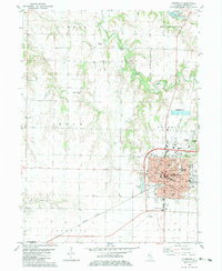
1982 Map of Monmouth
USGS Topo · Published 1983About this map
Monmouth serves as a significant regional center on this 1982 map, home to Monmouth College and an extensive network of educational institutions including Lincoln Sch and Garfield Sch. The town's infrastructure is well-defined by the Burlington Northern railroad and the Municipal Airport near Monmouth Park. Beyond the city limits, the landscape transitions into the agricultural townships of Sumner, Hale, and Lenox, where the settlement of Eleanor and the Sugar Tree Grove Ch provide focal points for rural community life.
Find a feature on this map
44 named features on this map. Tap any name to fly to it.
Don’t see what you’re looking for? This feature index may not catch every label — zoom into the map to look around manually.
Map Details
Editions of this 1982 Monmouth Map
This is the sole edition of this map. No revisions or reprints were ever made.
Other maps of this area

1921 · Monmouth
USGS Topo · 1:62,500

1923 · Monmouth
USGS Topo · 1:62,500

1923 · Alexis
USGS Topo · 1:62,500

1925 · Alexis
USGS Topo · 1:62,500

1934 · Oquawka
USGS Topo · 1:48,000

1935 · Keithsburg
USGS Topo · 1:48,000

1940 · Oquawka
USGS Topo · 1:62,500

1941 · Keithsburg
USGS Topo · 1:62,500

1958 · Burlington
USGS Topo · 1:250,000

1958 · Davenport
USGS Topo · 1:250,000