
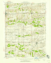
1923 Map of Alexis
USGS Topo · Published 1923About this map
Aledo and Alexis anchor a rural landscape dominated by an extensive network of one-room schoolhouses and small agricultural rail hubs during the early 1920s. The region is defined by the intersection of three major rail lines—the Chicago Burlington and Quincy, the Rock Island Southern, and the Minneapolis and St Louis—which facilitated the movement of coal and clay products from industrial pockets like Shale City and Wanlock.
Find a feature on this map
78 named features on this map. Tap any name to fly to it.
Don’t see what you’re looking for? This feature index may not catch every label — zoom into the map to look around manually.
Map Details
Editions of this 1923 Alexis Map
2 editions found
Other maps of this area

1912 · Milan
USGS Topo · 1:62,500

1916 · Edgington
USGS Topo · 1:62,500

1921 · Monmouth
USGS Topo · 1:62,500

1923 · Monmouth
USGS Topo · 1:62,500

1925 · Alexis
USGS Topo · 1:62,500

1925 · Galesburg
USGS Topo · 1:62,500

1927 · Galesburg
USGS Topo · 1:62,500

1934 · Oquawka
USGS Topo · 1:48,000

1935 · Keithsburg
USGS Topo · 1:48,000

1937 · Orion
USGS Topo · 1:62,500