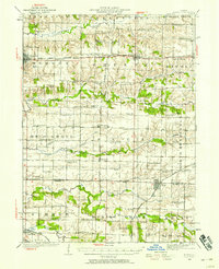
1923 Map of Alexis
USGS Topo · Published 1958About this map
Edwards River meanders through the northern reaches of this Illinois prairie landscape, where the rural economy of the early 1920s is marked by a dense network of country schoolhouses. Named for local landmarks or family estates, these institutions like Maple Grove School, Silver Lake School, and the specialized Carbon High School served as the primary social anchors for a farming population. The village of Alexis sits at the intersection of three counties, while industrial activity is evidenced by Shale City and the coal-related naming of Carbon High School. The regional transportation network is dominated by the Rock Island and Southern and the Chicago Burlington and Quincy railroads, which facilitated the movement of agricultural goods and passengers between centers like Aledo and Viola. The map preserves the specific locations of long-lost rural corners such as Alexis Junction and Shadyside School.
Find a feature on this map
84 named features on this map. Tap any name to fly to it.
Don’t see what you’re looking for? This feature index may not catch every label — zoom into the map to look around manually.
Map Details
Editions of this 1923 Alexis Map
2 editions found
Other maps of this area

1912 · Milan
USGS Topo · 1:62,500

1916 · Edgington
USGS Topo · 1:62,500

1921 · Monmouth
USGS Topo · 1:62,500

1923 · Monmouth
USGS Topo · 1:62,500

1923 · Alexis
USGS Topo · 1:62,500

1925 · Alexis
USGS Topo · 1:62,500

1925 · Galesburg
USGS Topo · 1:62,500

1927 · Galesburg
USGS Topo · 1:62,500

1934 · Oquawka
USGS Topo · 1:48,000

1935 · Keithsburg
USGS Topo · 1:48,000