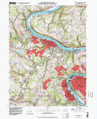
1993 Map of Monongahela
USGS Topo · Published 1999About this map
The Monongahela River carves a deep, industrial path through the heart of Pennsylvania's coal and steel country in this 1990s record. The densely developed riverfront towns of Monongahela, Monessen, and Charleroi are mapped in detail, showing a landscape defined by riverside infrastructure including conveyors, the powerhouse, and numerous mines. Away from the urban centers, smaller settlements like New Eagle and Van Voorhis sit among winding tributaries like Pigeon Creek.
Find a feature on this map
90 named features on this map. Tap any name to fly to it.
Don’t see what you’re looking for? This feature index may not catch every label — zoom into the map to look around manually.
Map Details
Editions of this 1993 Monongahela Map
This is the sole edition of this map. No revisions or reprints were ever made.
Other maps of this area

1901 · Amity
USGS Topo · 1:62,500

1902 · Brownsville
USGS Topo · 1:62,500

1904 · Amity
USGS Topo · 1:62,500

1904 · Mc Keesport
USGS Topo · 1:62,500

1904 · Carnegie
USGS Topo · 1:62,500

1906 · Brownsville
USGS Topo · 1:62,500

1906 · Carnegie
USGS Topo · 1:62,500

1907 · Pittsburg
USGS Topo · 1:62,500

1908 · Carnegie
USGS Topo · 1:62,500

1931 · Brownsville
USGS Topo · 1:62,500