1922 Map of Monroe
USGS Topo · Published 1922About this map
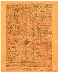
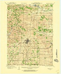
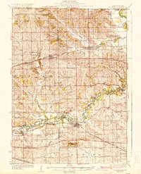
The city of Monroe serves as the focal point of this 1922 survey, showing a dense grid of streets at the intersection of the Illinois Central and the Chicago Milwaukee and St Paul railroads. This era was defined by a landscape of small agricultural districts, evidenced by the high density of named country schools such as Hardscrabble School, Dry Goods Box School, and Jordan Center School. South of the city, the County Farm and settlements like Schueyville and Twin Grove reflect the established rural community near the Wisconsin-Illinois state line.
Find a feature on this map
78 named features on this map. Tap any name to fly to it.
Don’t see what you’re looking for? This feature index may not catch every label — zoom into the map to look around manually.
Map Details
Editions of this 1922 Monroe Map
This is the sole edition of this map. No revisions or reprints were ever made.
Other maps of this area

1889 · Evansville
USGS Topo · 1:62,500

1893 · Brodhead
USGS Topo · 1:62,500

1894 · Evansville
USGS Topo · 1:62,500

1906 · Evansville
USGS Topo · 1:62,500
1920 · Monroe
USGS Topo · 1:62,500

1923 · Blanchardville
USGS Topo · 1:62,500

1923 · New Glarus
USGS Topo · 1:62,500
1923 · South Wayne
USGS Topo · 1:62,500
1932 · Pecatonica
USGS Topo · 1:62,500
1936 · Pecatonica
USGS Topo · 1:62,500